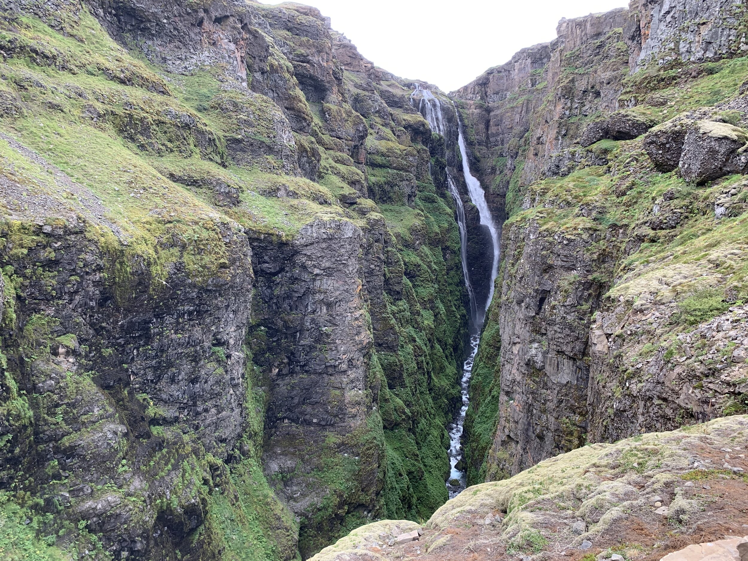
Glymur:Iceland’s (almost) tallest waterfall!
This weekend we decided to get our walking boots on and go hiking. Colleagues had told me about the hike up to the top of Glymur waterfall and it sounded pretty incredible so we decided to give it a go. It certainly didn’t disappoint! Until recent years it was thought to be the highest waterfall in Iceland with a drop of 198m (650ft), until scientists discovered another one in the Vatnajökull glacier in 2011 with an even longer drop. But Glymur is definitely the tallest waterfall that is easily accessible and is quite magnificent. This is a hike I would most definitely recommend. Given that it is only an hour from Reykjavík it is easy to fit into even a short stay in Iceland and even the drive there and back is beautiful as you drive along the edge of the Hvalfjörður fjord.
FACTS ABOUT THE HIKE
Distance: 7 km (4.3 miles)
Total Ascent: 425 meters (1394 feet)
Difficulty: Moderate
Length of Time: 3 to 4 hours
When to go: The best time to go is from June to September, when there is no snow on the ground and the log is in place for the first river crossing. The remainder of the year, this hike can be dangerous when snow covers the trail.

We chose to climb the south side (red) and then cross the river and descend the north slopes (yellow)
Luckily I did a bit of research beforehand and so we went prepared with walking poles and with water shoes (for the second river crossing), bottled water and snacks in our rucksacks. As a whole the hike isn’t too difficult, but some of the sections are quite tricky and it can get slippery if there has been any rain, so ropes have been provided on some of the steeper sections to hang on to. I have to say, without the ropes I don’t think I’d have made it!
We decided to take it easy, spent lots of time taking photos and also stopped for a picnic lunch, so we took around 4½ hours from start to finish.
The first bit of the hike was quite easy and relatively flat as we made our way along the valley towards the river for the first river crossing. Surrounded by lupins and cotton grass and accompanied by sheep this section was very pleasant and we soon got to the first landmark on the route - the lava cave. The path narrows and seems to disappear off left into nowhere until you notice a cave entrance. Making your way into the cave you are rewarded with amazing views of the valley and the first river crossing.


Once through the cave, we soon came to the Botnsá River, ready to cross using the log and cable provided.
THE FIRST RIVER CROSSING
As we approached, we could see the first crossing ahead. It looked more scary than it is - the log is wide enough to walk across with relative ease, particularly using the cable provided. However, the log is only there in the summer months - as autumn sets in and the river gets higher the log can be completely submerged under fast-flowing water and is removed until the following spring/summer.


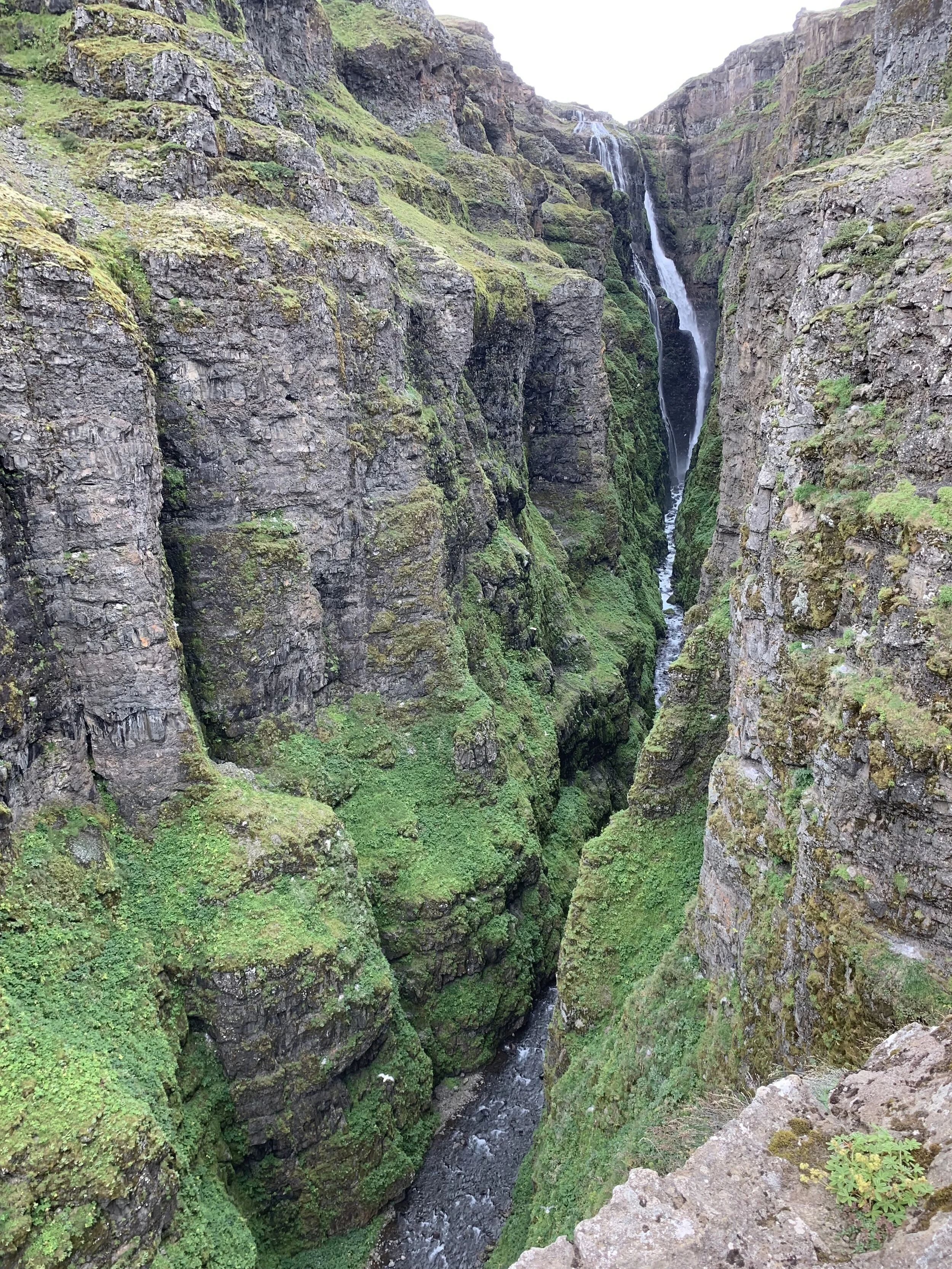
From here, the route became far trickier as we began to climb. At times the trail is steep and there are several points where the trail is quite narrow and located right on the edge of the cliff so if you have a fear of heights this will be very challenging. There are also several places where you have to cross small streams so care has to be taken with slippery rocks. But as we climbed the views got better and better. It is worth taking time to enjoy it, rather than focusing on getting up as fast as possible (that was our excuse anyway as we let younger and fitter hikers overtake us) as quite often the view looking back the way we’d come was as stunning as the views ahead of us. As you climb, the waterfall itself comes into view and the higher you clamber the better the views of the deep gorge, with gorgeous green moss-covered rocks and Glymur itself thundering down ahead of you. One of the loveliest things to watch was the fulmars as they wheeled and circled the gorge, catching the air currents and seeming to tease us as they sailed past us - just too quickly to get good photos of them. Pictures don’t even begin to do the majesty and beauty of this hike justice, but here are a few.

The view looking back at the Botnsá River and the cave

We encountered several other little waterfalls on the way up


Almost at the top
THE SECOND RIVER CROSSING
As we kept climbing, beyond the top of the waterfall itself, we saw the river above flattening out into a wide shallow river. This is the point at which you can decide whether to turn round and go back down the way you came, or to cross the river and continue down the north side of the gorge back to the car park. Given how narrow and steep some of the paths had been climbing up, I was all for the river crossing and an easier trek back!! Plus the fact the river crossing is part of the experience, and the reason we’d brought our water shoes. Although the river is wide and shallow with slow-flowing water, there is no log or bridge so the only way to cross is to roll up your trousers, take off your walking boots and get wet! Given how slippery some of the rocks are I would definitely advise wearing water shoes or scuba boots with rubber soles. It is perfectly possible to cross barefoot but it is slippery and very cold. However, it was definitely one of the most fun parts of the hike.

Yesss! We’d got to the top in one piece and managed not to slip and fall in!

THE DESCENT
As we started along the north side of Glymur the landscape was completely different; flatter and more like a mountain meadow and the going was definitely easier. The route we took followed the gorge for a short while and then we had the option to take a longer but shallower descent which we did, stopping on the way for a picnic lunch overlooking the fjord. Although we had none of the perilous cliff paths and steep scrambles using ropes to hold on to, we still had to pay attention as there was a great deal of loose rocks and scree and it would have been easy to slip and fall.

There can’t be many better lunch views than this!

Resting tired feet while we ate and checked out the path down to the car park
After the challenges of the ascent, it was a relief to worry about little more than where we were putting our feet and make sure we didn’t slither down the steeper sections of the path, but to be honest I wouldn’t have missed the climb up the south side for the world. Yes it was scary but I wouldn’t have felt I’d done the hike justice if we hadn’t met the challenge. Given how frightened I was at times, I’m very proud indeed to have hiked Glymur!
