The Golden Circle


No Iceland blog would be complete without something about the Golden Circle. Rather than a specific place, it’s a 186 mile route that takes in three of the most popular natural attractions in Iceland which makes it an easy and efficient way to see three of Iceland’s top attractions in as little as half a day (depending on how much time you want to spend at each). This is why so many coach tours do the Golden Circle route as you get a lot packed in in a short time, and it is Iceland’s most popular sightseeing trail, and features near the top of almost every list of things to do over here.
The three attractions that make up the Golden Circle are Þingvellir National Park, the Geysir geothermal area and Gullfoss waterfall. All are well worth a trip in their own right, so to be able to see them all in a half day is an added bonus.
However, we found that although we did just that when I first came over, we have revisited all the attractions since, and found plenty of other lovely places to visit within the same area. However, for the moment I will focus on the Big 3.
Þingvellir
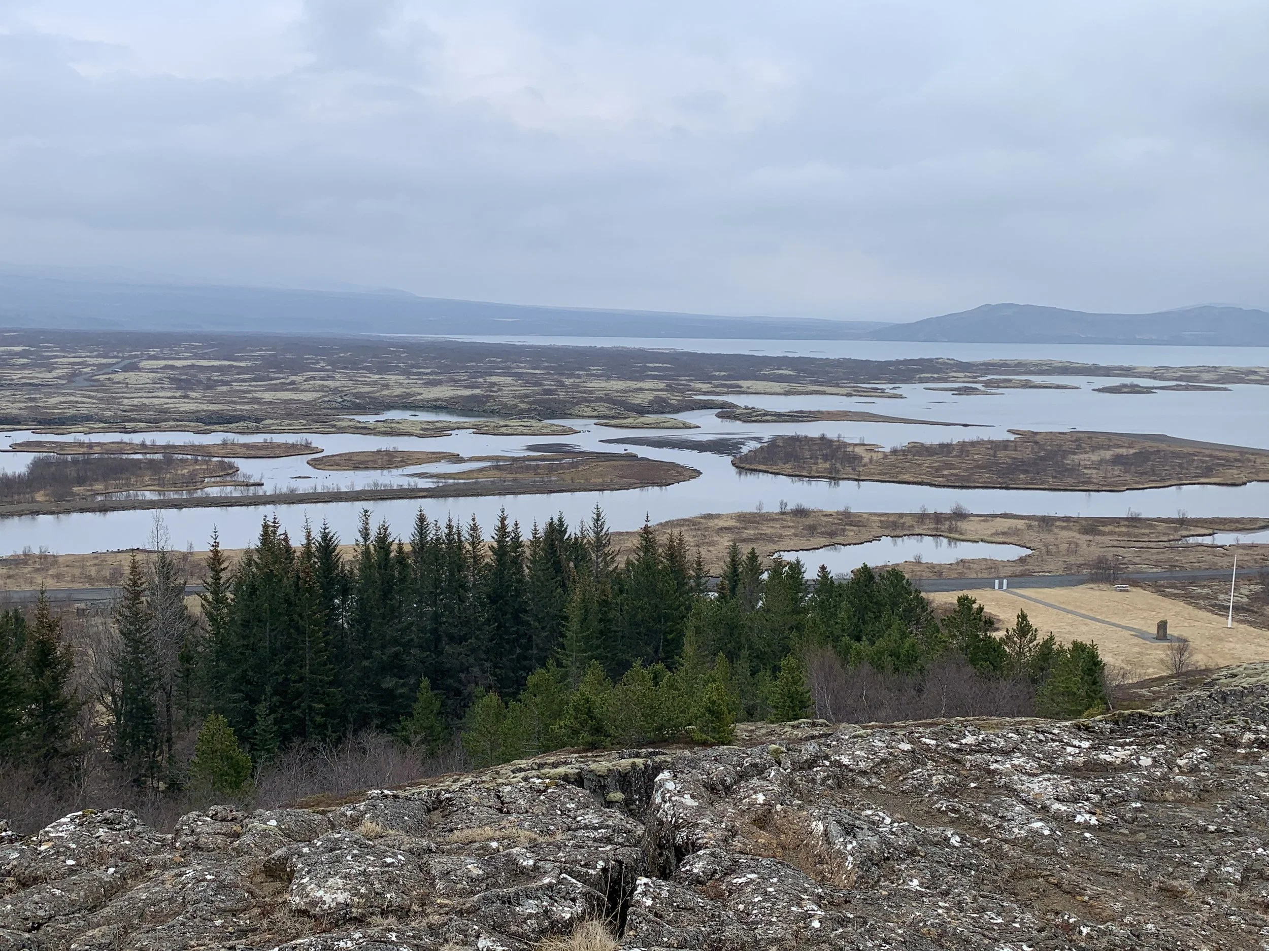
Þingvellir National Park is an amazing site steeped in history and folklore and surrounded by incredible geology, which comes from its location between the North American and Eurasian tectonic plates, which create the rift valley that runs through Iceland. Iceland is the only country where this valley, the Mid-Atlantic Ridge, can be seen above sea level.
When you enter the park from Reykjavik, you drive towards a sheer cliff that is, in fact, a corner of the North American continent. The Eurasian continent is several miles away, on the far side of the park, and is equally dramatic to look at once you reach it.

One of the first views of Þingvellir
A magma pocket formed between these plates, rising as they moved apart. Apparently, this venting was responsible for creating Iceland millions of years ago!! The fact that they are continuing to separate and move apart (albeit very very slowly) is the reason that Iceland has such fascinating volcanic activity. The island is still young and remains very much in the formation process.
You can see evidence of this process all across Þingvellir. There are long stretches of lava rock, and many volcanoes surround the park, rising above Þingvallavatn, Iceland's largest natural lake.

The last eruption here was over 2,000 years ago and the park has now grown over with vegetation. The lava fields are covered in moss and many parts of the area are forested with native birch trees and imported pines.
There are still regular earthquakes in the area, each one partly responsible for the distance between the plates widening an inch (2.5cm) a year.

The ravines that get opened up by these earthquakes fill up with meltwater from the Langjökull glacier which then makes its way underground through porous lava rock towards the Þingvallavatn lake. This filtration process leaves the water crystal clear, which is part of the reason the lake is so beautiful, but also has the benefit that visibility within the water exceeds 100 metres.

The beauty of the lake
The most famous of these ravines is the Silfra fissure, where diving and snorkelling expeditions are organised, taking full advantage of the incredible visibility and amazing underwater geology, as you get the chance to dive between the two tectonic plates – a world between two continents. Silfra has been voted one of the top ten dive sites in the world; an otherworldly scene of crystal clear water in many shades of blue.
However, the reason Þingvellir received National Park and UNESCO World Heritage Site status is not due to its landscape or geology but its history. No single place epitomizes the history of Iceland and the Icelandic nation better than Þingvellir by the river Öxará.
The name Þingvellir means "Assembly Plains" or “Fields of Parliament” and it is here that the Alþing general assembly was established around 930 and continued to convene there year after year for centuries. Since its establishment over a millennium ago, the parliament was only interrupted for one period, from 1799 to 1844. After that, it was relocated to Reykjavik, but its function has remained the same. This makes the Icelandic parliament the oldest ongoing representative parliament in the world.
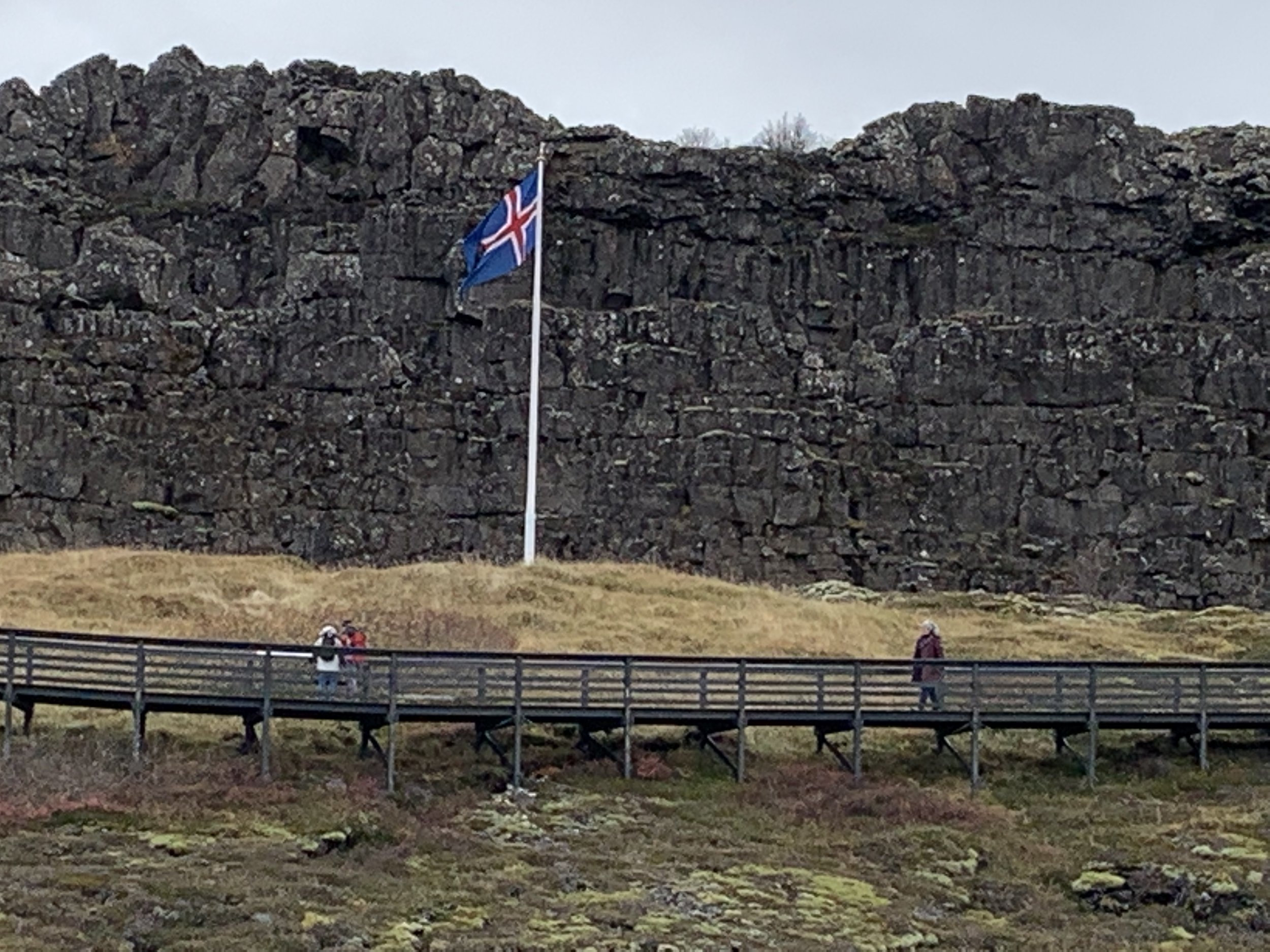
The site of the Alþing parliament
Major events throughout the history of Iceland have taken place at Þingvellir and therefore the place is revered by all Icelanders. Today Þingvellir is a protected national shrine. According to the law, passed in 1928, the protected area shall always be the property of the Icelandic nation, under the preservation of the Alþing.
However, Þingvellir has a darker history too. It was also a place of judgement and punishment, until 1800 as some of the place names in the park testify. For example Gálgaklettur (Gallows Rock), Gálgaeyri (Scaffold beach), Brennugjá (Burning Gap) and Drekkingarhylur (the Drowning Pool). This last is still there and an information board tells of the 18 women who were known to have been drowned in the Drowning Pool (usually as the result of an accusation of loose morals). Just a few moments away from the place where the parliament was held is this shallow pool with such a sad history. There is now a bridge over the pool which has changed the landscape, making the pool smaller and shallower (thank goodness!). Hard to think that such a picturesque place was the scene of such tragedy. There is now a memorial plaque at the site with the names of the women.
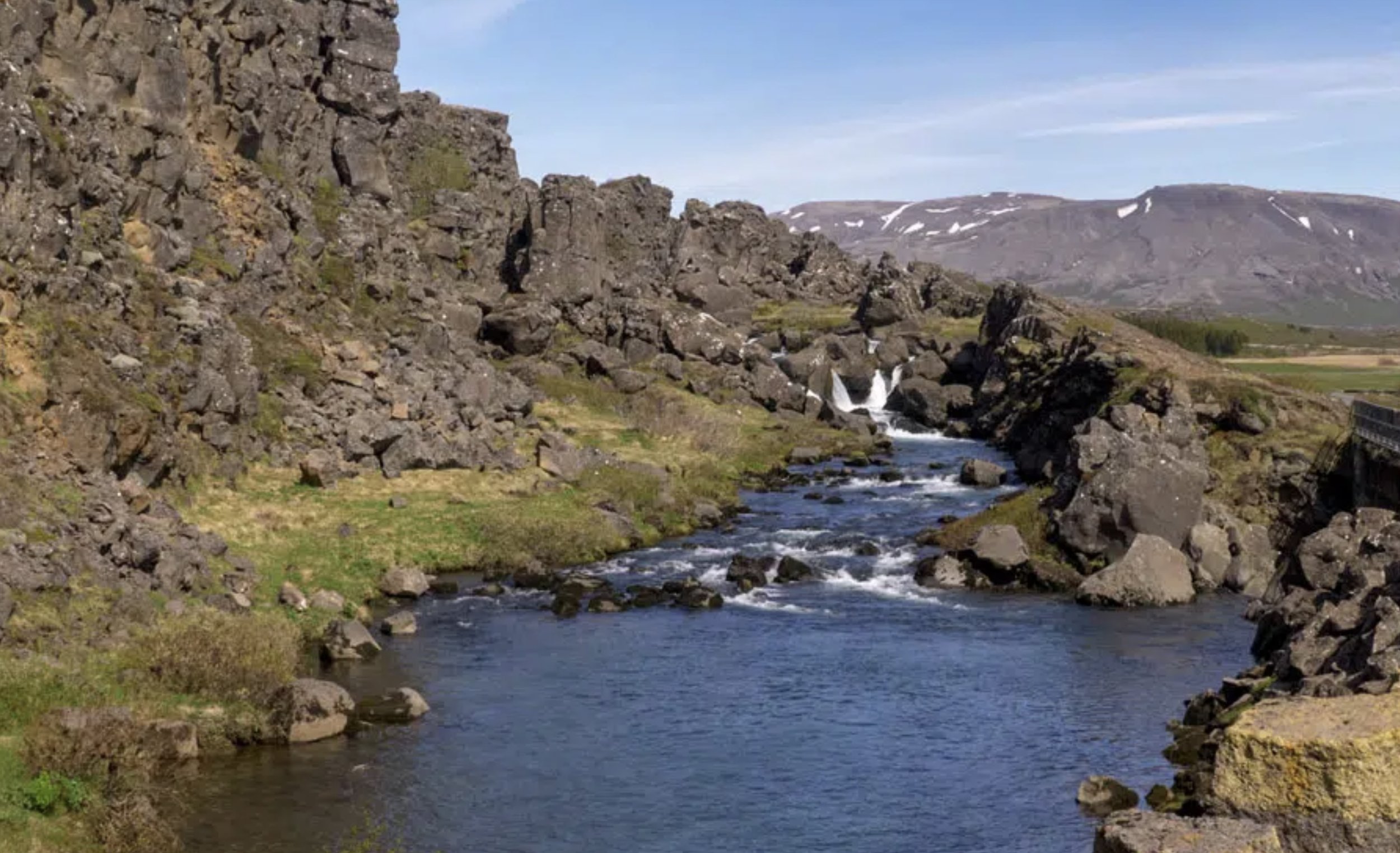
The drowning pool
Another thing that Þingvellir is known for is its animal life. Birdwatchers flock here in the summer to see the many species of duck, the golden plovers and common snipes. Arctic foxes and mink can also be seen here and the lake is famous for its fish. There are only five species of freshwater fish found in Iceland and three of them live in Þingvallavatn (Þingvellir Lake) Arctic Char, the Three-spined Stickleback and Brown Trout which, due to thousands of years of isolation after the glacier water lake became cut off at the end of the last ice age are very large for their kind. In fact, every autumn the locals come in their hundreds for the annual ‘Trout Walk’ at Þingvellir Lake. I have written a separate blog post about the Trout Walk - or Dance.
The Geysir Geothermal Area
This is located in Haukadalur, a geothermal valley within the Golden Circle area and it can be seen from quite some way away. As you approach, the landscape becomes more dramatic and it’s possible to see plumes of steam dotted about, near the road. Many of these are located around the village of Laugarvatn (where the Fontana geothermal spa has been built to take advantage of the hot water currents under the surface of the ground). As you approach Haukadalur the geothermal activity becomes even more intense – you can see the steam rising from miles away. The whole area is dotted with hot pools, clay pots, and fumaroles.

Some of the hot pools around Geysir
Before long you see the Geysir Centre by the side of the road, with a large car park. Here, there is a large craft/clothing shop, the Geysir Hotel and also a couple of restaurants serving traditional Icelandic food. I have been told that the lamb sandwiches there are the best around, although we haven’t yet tried them, as when we went we were seduced by the fish soup – which was phenomenally good – with huge chunks of fish in the bottom, making it a very satisfying meal indeed.
Opposite the Geysir Centre is the area where the geysers themselves can be found. The oldest and most famous is Geysir itself – this is the geyser that has given all others their name. Geysir is the earliest documented geyser in European literature, and its name comes from the Old Norse verb 'to gush.'
Geysir rarely erupts, and years can go by between eruptions, so if you see it, you are very lucky indeed! It is currently inactive these days because of local tectonic activity and intrusive human intervention. Studies show that it has existed for about 10,000 years and tends to erupt in cycles. Usually, an earthquake will trigger it, and it will then slowly peter out over time. But apparently, even when it's erupting, it's unpredictable in both timing and consistency. For example, in the early 1910s, it was known to erupt every half-hour, yet its activity had almost ceased by 1916.
Tired of the fact that their country's most famous landmark was so inconsistent, Icelanders dug a channel into the silica rim around Geysir's vent in 1935 to lower the water table and encourage it to go off again. Although it worked for a short time, the channel became clogged, and activity ceased once more. The channel was cleared in 1981, and it was found that Geysir could be made to erupt by pumping soap into it. There were many concerns about this activity's environmental impact, and it was stopped in the 1990s, since when it has been mostly dormant, although it did suddenly erupt in 2000, with a jet of water reaching some 122 metres (400 feet) into the air!
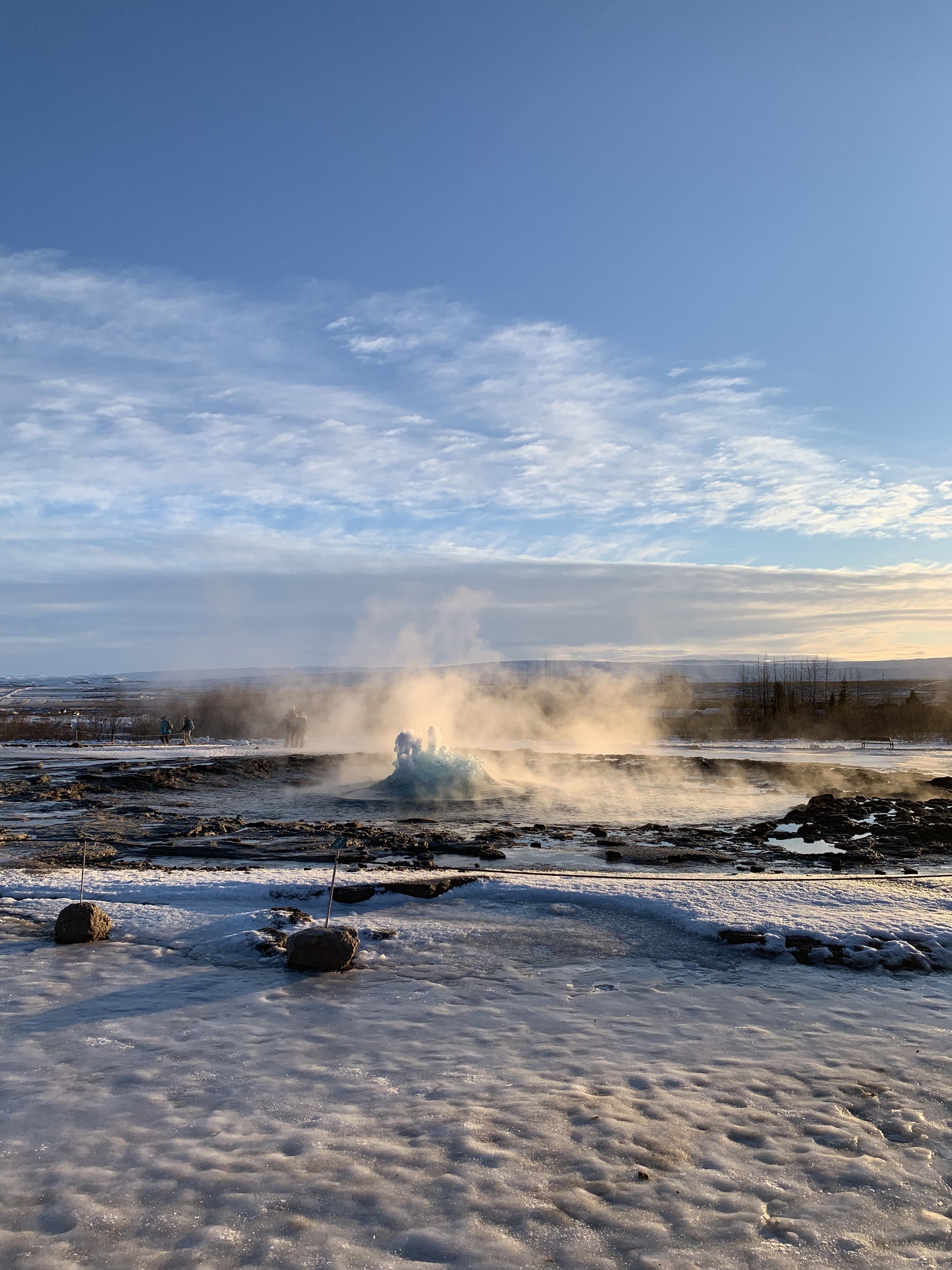
However, luckily for us, there is a neighbouring – and much more reliable – geyser, called Strokkur, which is probably now Iceland’s most famous hot spring, sending jets of boiling water anything from 20 to 40 metres (65-130 feet) up from the ground. Strokkur is incredibly active, erupting every five to ten minutes, so it is worth hanging about with camera at the ready because it will never be too long until it goes off.

The first thing you see is the water around the geyser hole seeming to momentarily sink then suddenly rising up in a perfect semi-sphere from the ground, when suddenly the jet of hot water erupts from the dome of water to the delight of those gathered around. Almost as soon as it has erupted, it dies down again to remain dormant for the next ten minutes or so until again, almost without warning it suddenly gushes up into the air.
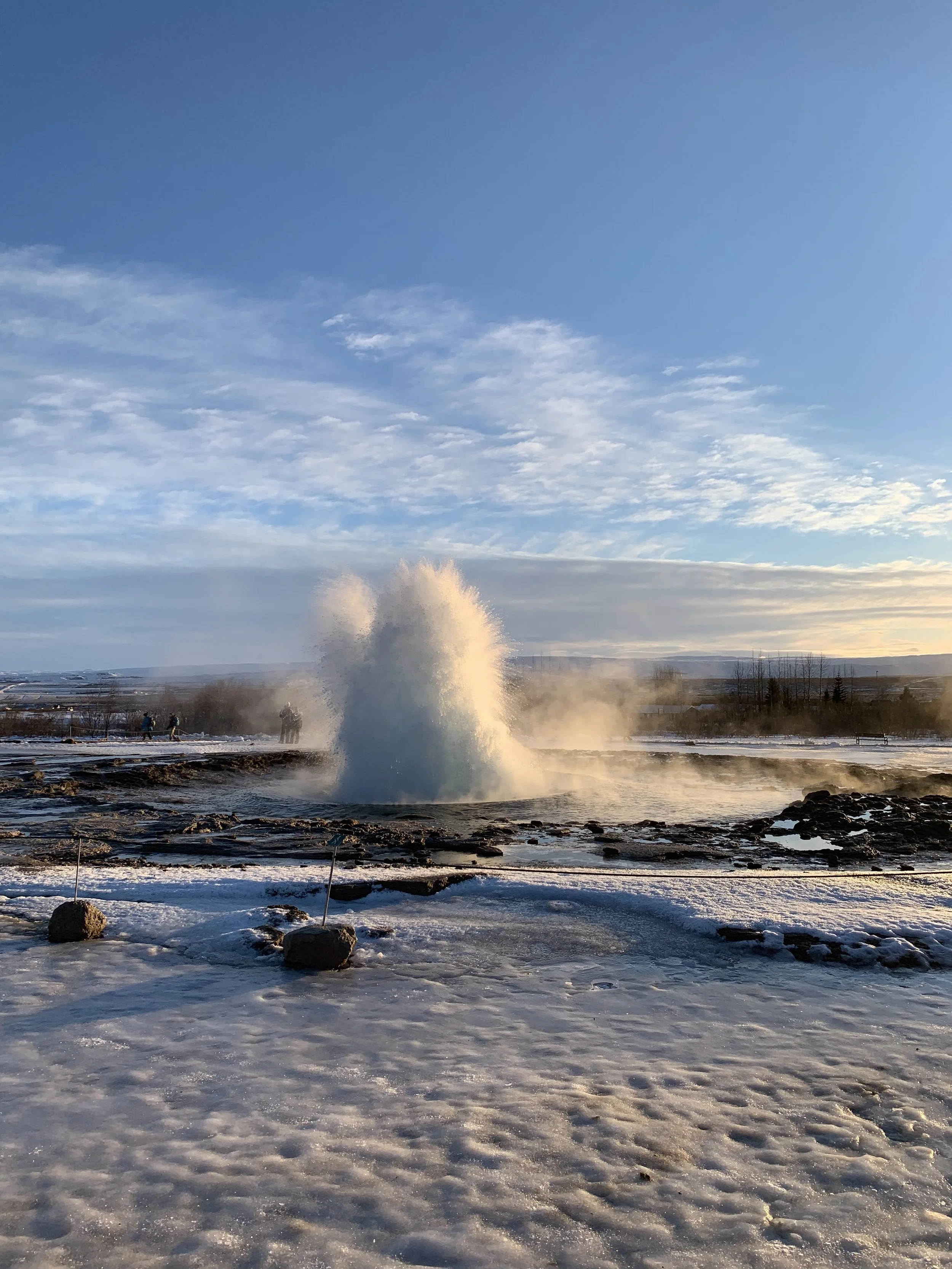

Every now and then, you get a double eruption, the first dying away to suddenly become a second, often higher jet of water, catching everyone unawares. We were incredibly lucky when we went to see a triple eruption! The next few were smaller and less powerful, as if Strokkur needed to recoup its energy and resources before sending another huge jet skywards again. But when it does, the jet of water absolutely dwarfs the people gathered around, it really is huge.

A geyser so active and reliable and in such an accessible location is part of what makes the Golden Circle such an amazing place. Geysers are a rare natural phenomenon, and to have one that erupts so regularly is really quite incredible.
Walking around the Geysir Geothermal Area with its pillars of steam, its bubbling hot pots and the ground stained yellow/orange from the sulphur in the water is a fascinating and rewarding experience, and it’s hard to leave. You find yourself hanging around Strokkur, waiting for ‘just one more’ eruption, again and again. There is something quite mesmerising about this incredible spectacle of nature.

Gullfoss Waterfall
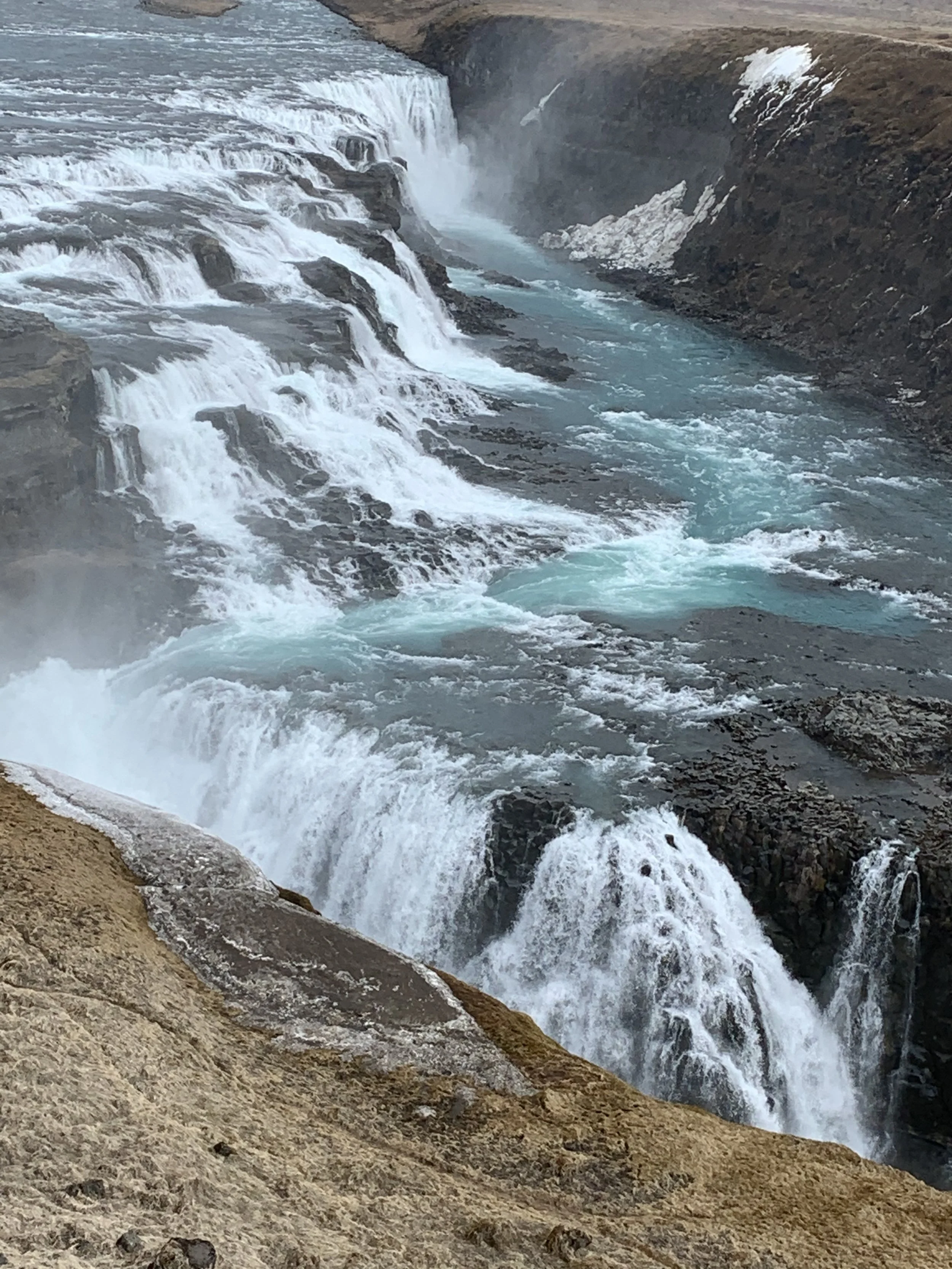
The third and final stop on the Golden Circle route, less than 10 minutes down the road from Geysir, is one of the most spectacular waterfalls in Iceland: Gullfoss. Gullfoss means ‘Golden falls’ and gets its name from the fact that on a sunny day, the water takes on a golden-brown colour. This is due to the fact that it is made up of glacial water from the Hvítá river (meaning ‘White River’) and therefore carries lots of sediments that glacial ice has carved off the earth throughout the years. I presume that Gullfoss is the reason for the Golden Circle route getting its name as it is the biggest and most popular attraction in the area. Although I call it a waterfall, it is actually two waterfalls – or at least two distinct drops in succession at right angles to each other which span the entire width of the Hvítá River.

Gullfoss in early spring seen from the top viewing platform
This powerful waterfall tumbles down its two drops from an overall height of 32 meters (105 feet). During the summer, it pours an average of 140 cubic meters (4,944 cubic feet) of water every second.
The best season to visit Gullfoss (indeed most of Iceland’s waterfalls) is probably summer. When there's no ice on the ground you can go via a walkway right up to the edge of the falls, close enough to feel the spray on your face. In the winter this is closed, and you cannot get anywhere near as close. However, it is still beautiful, and at this time of year you can see sections of it where the water is actually frozen in mid-tumble.

And in the winter, snow and ice changing the entire landscape
The disadvantage of visiting in the winter is that it is bitterly cold, with winds that come straight from the Langjökull glacier, that supplies the water for the Hvítá river and Gullfoss waterfall.
Gullfoss is one of the most famous and visited waterfalls in Iceland and is an incredible sight. It is also, if the stories are to be believed, a sight that might have no longer existed but for the courage and tenacity of one woman, Sigríður Tómasdóttir.

The lower drop into the ravine below
In the early 20th century, foreign investors saw a huge opportunity to add a dam to Gullfoss and turn it into a hydroelectric plant. The owner of the falls at the time was a sheep farmer named Tómas Tómasson. While Tómasson declined to sell the rugged area to an Englishman who wanted to build a hydroelectric plant, he did agree to lease his land to generate power.
It was a decision that deeply troubled his daughter. She fretted over what might happen to her beloved falls. Though not formally educated herself, the artistic woman dug into her savings and sought a lawyer for help: Sveinn Björnsson, who years later would become Iceland’s first president. In court they argued that the rental agreement should be cancelled, but the case dragged on for years.

She protested so intensely against the development plans that she threatened to throw herself into Gullfoss and kill herself if the dam went ahead. She even walked the 134 miles (200 kilometers) of unpaved road to Reykjavik and back again multiple times to rally a legal case in Gullfoss's defense, apparently on one occasion even walking barefoot! Although her actions did not directly save the waterfall, they drew attention to the case. This awareness led to national criticism of the plans and ensured that the dam-building process was delayed. Eventually the investors were persuaded to annul the contract. Before Sigríður died a new law forbade foreign nationals from purchasing a state-owned waterfall. Gullfoss became a national park in 1979.

Today, Sigríður is immortalized in a stone memorial on top of the waterfall. Icelanders remember her as a hero for her efforts to save it and she is considered to have helped pave the way for feminism and environmentalism in Icelandic culture.
Stand above the rushing currents of Gullfoss and it’s easy to understand why Sigríður Tómasdóttir fought so hard to protect one of Iceland’s most iconic views. It is stunning in pretty much any weather, although on a sunny summer’s day it will not only look at its golden best, but will probably have many rainbows from the combination of sun and spray.
We’ve had the opportunity to visit in early spring and again in the winter, so it is a trip that we will definitely make again on one of those sunny days of summer. Watch this space….

The beauty of Gullfoss falls, a sight worth preserving
