A weekend away in Fljótshlíð

A view across the Fljótshlíð area from the side of Stóra Dímon
Last week we finally had a weekend that was not forecast to have dreadful weather. Admittedly, it was set to rain in most of Iceland, but given the exceptionally cold and snowy winter we have had this year, a bit of light rain felt almost tropical!! Particularly as the temperature was reasonably mild and there was relatively little wind forecast, so we rapidly decided to book a last-minute cabin somewhere out of Reykjavík and get out and about for a bit of exploring and fresh air. It was a wonderful prospect after being unable to do much travelling at all since a few weeks before Christmas.
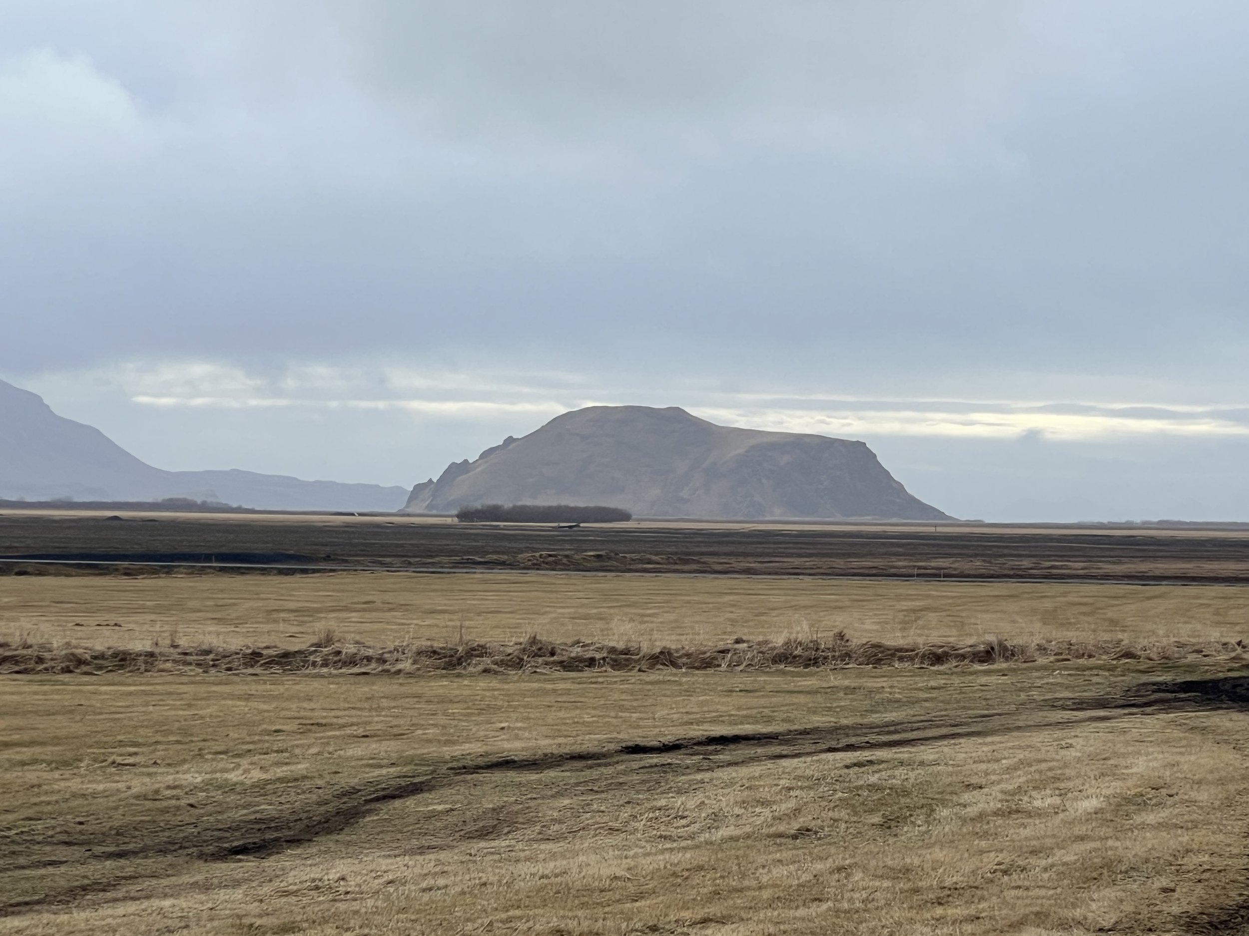
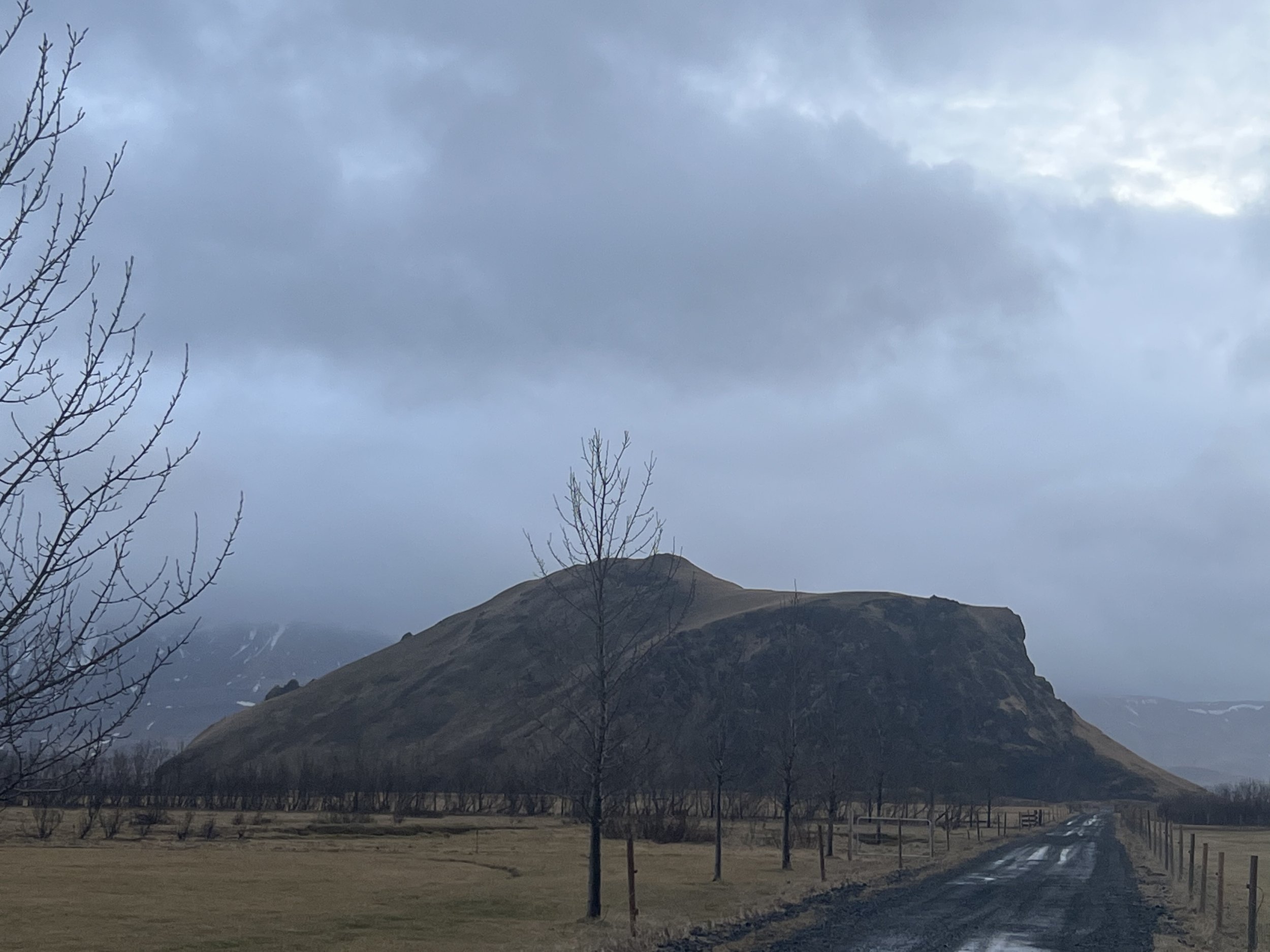
Stóra Dímon, the big little mountain, that dominates the Króssa estuary
As it was very last-minute and we only had the one night, we decided not to go too far from the capital, so we headed off to a little cabin that we managed to book, located on a working farm in the Fljótshlíð area. Fljótshlíð is a beautiful farming district in Southern Iceland. It is one of the main sites for Njál's Saga, a masterpiece of Icelandic saga literature. It is surrounded by some of the most active and best known volcanoes in Iceland, including Hekla, Katla and Eyjafjallajokull (the one that caused the ash cloud that stopped air traffic globally in 2010) and is within the Katla Geopark. This is an area that is pretty familiar to us as the main Route 1 ring road passes through it along the south coast, and it is home to a number of famous and much-visited tourist spots such as Seljalandsfoss and Gljúfrabúi. It is also from this area that you can catch the ferry across to Vestmannæyjar so we have got to know it quite well.

A view across the Króssa estuary towards Seljalandsfoss and the coast
The reason we chose Fljótshlíð as our destination of choice was because I wanted to visit the Nauthúsagil canyon. Last year we went to Þórsmörk on a guided tour, and on the way back we stopped briefly at Nauthúsagil (which means Bull Shed Canyon) but due to time constraints we hadn’t had the chance to explore it. I decided that this was a trip that wouldn’t be spoiled by a bit of rain so the decision was made. Nauthúsagil is a pretty gorge that it is possible to explore by clambering/wading up the river. The ravine is well-known for the rowan that grows on its ridge. In places the many rowan trees that grow all along the cliff sides of the gorge itself lean over the ravine, some almost horizontally, and almost meet overhead, creating a bit of a tunnel. It is a lovely sight when the tree is in full bloom. The hike up Nauthúsagil necessitates not only wading up the river, but clambering up a small 2-3m high waterfall and then continuing up the river which leads to a bigger and very picturesque waterfall…. This sounded like fun so we decided to go for it.
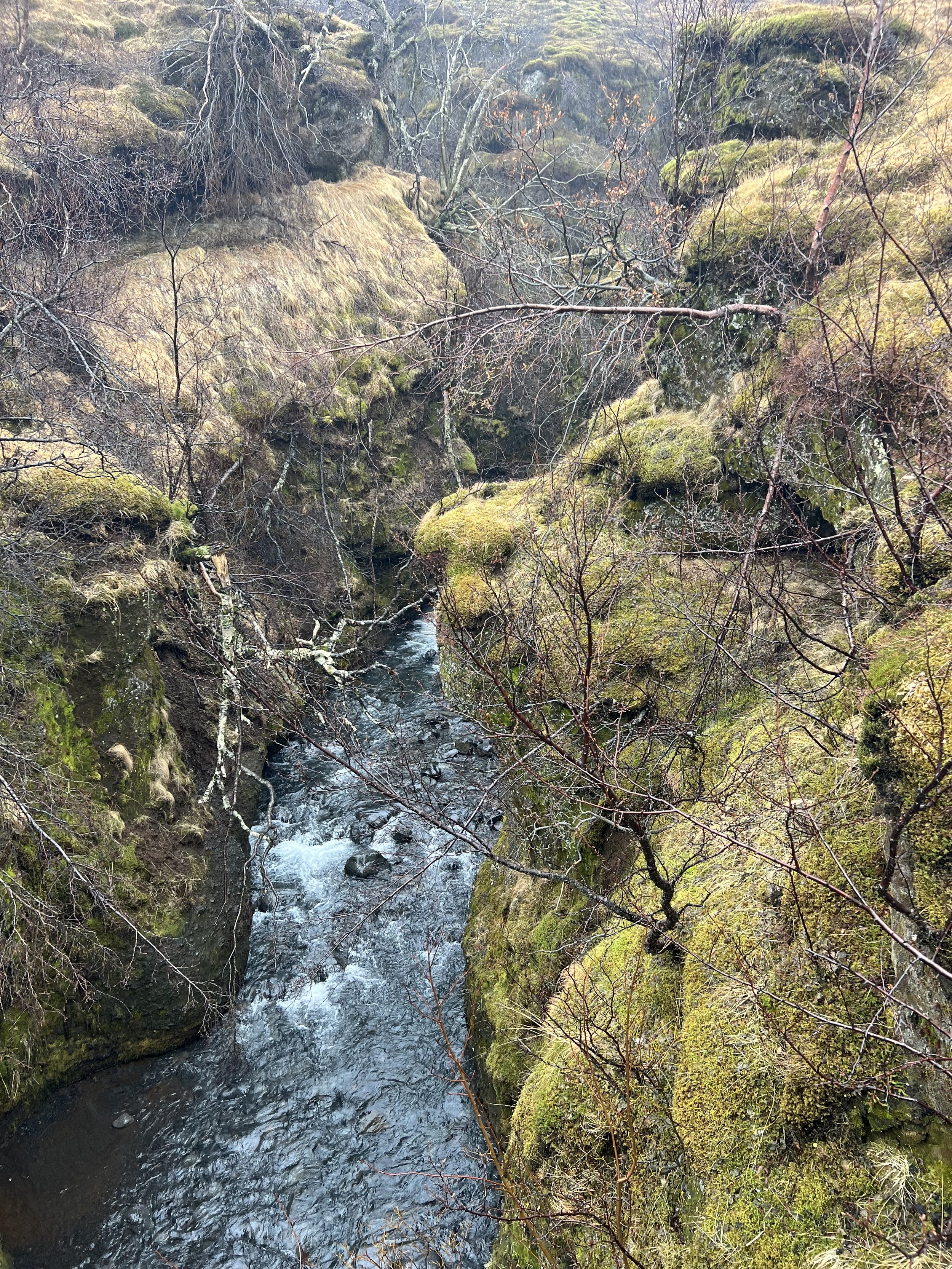

Looking down at the ravine and the rowans which in the summer create a roof over the top
We arrived at Nauthúsagil towards lunchtime and despite it being a little colder than we’d expected and rather wet with a steady drizzle, we headed from the car parking area up to the mouth of the gorge. However, we were rather concerned to discover that, due to the recent snow melt and heavy rains, the level of the river was a lot higher and the river was a lot faster than we remembered. When we saw that the small wooden bridges that used to span the river had all been washed away, and saw them broken and battered further downriver, we decided that perhaps wading up might not be the most sensible idea ever!
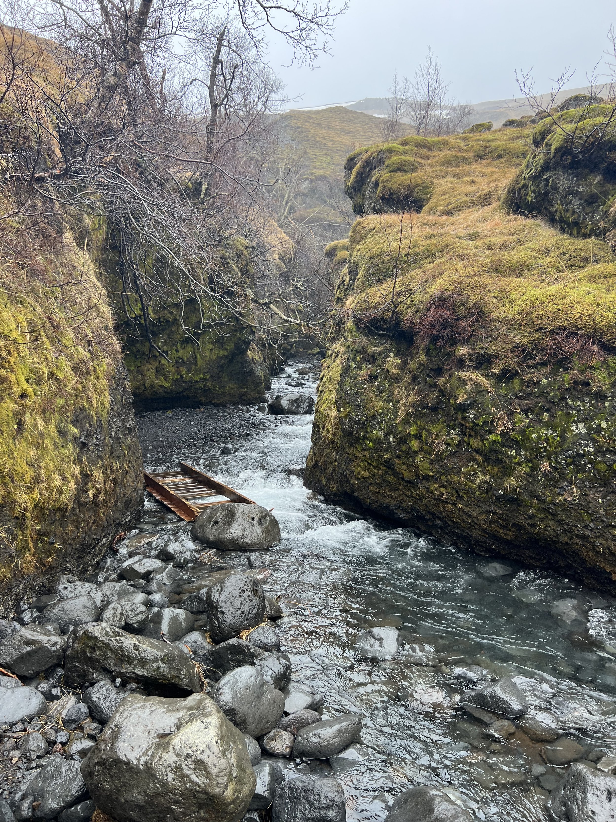
One of the wooden bridges that had not withstood the recent high water levels
Not only that but there was no one else there, so had we got into trouble there would have been no one to ask for help, so reluctantly we decided to save the canyon for another day. Instead we decided to climb the hillside and follow the canyon from above, having read that it makes quite a pleasant climb and that there is another waterfall further up that cannot be seen from the canyon itself. So we found the shallowest part of the river that we could and waded across to the marginally more climbable side of Nauthúsagil. There is a track up the steep slope and the occasional marker posts so we were able to reassure ourselves that we were pretty much on the right path as we climbed up the mountainside. Before long we saw a long narrow waterfall to our right which was quite picturesque and there were various points where we could make our way towards the edge of the gorge on our left and look down at the hike we should have taken.


(Left) One of the waterfalls on our hike and (right) looking down into Nauthúsagil ravine from above
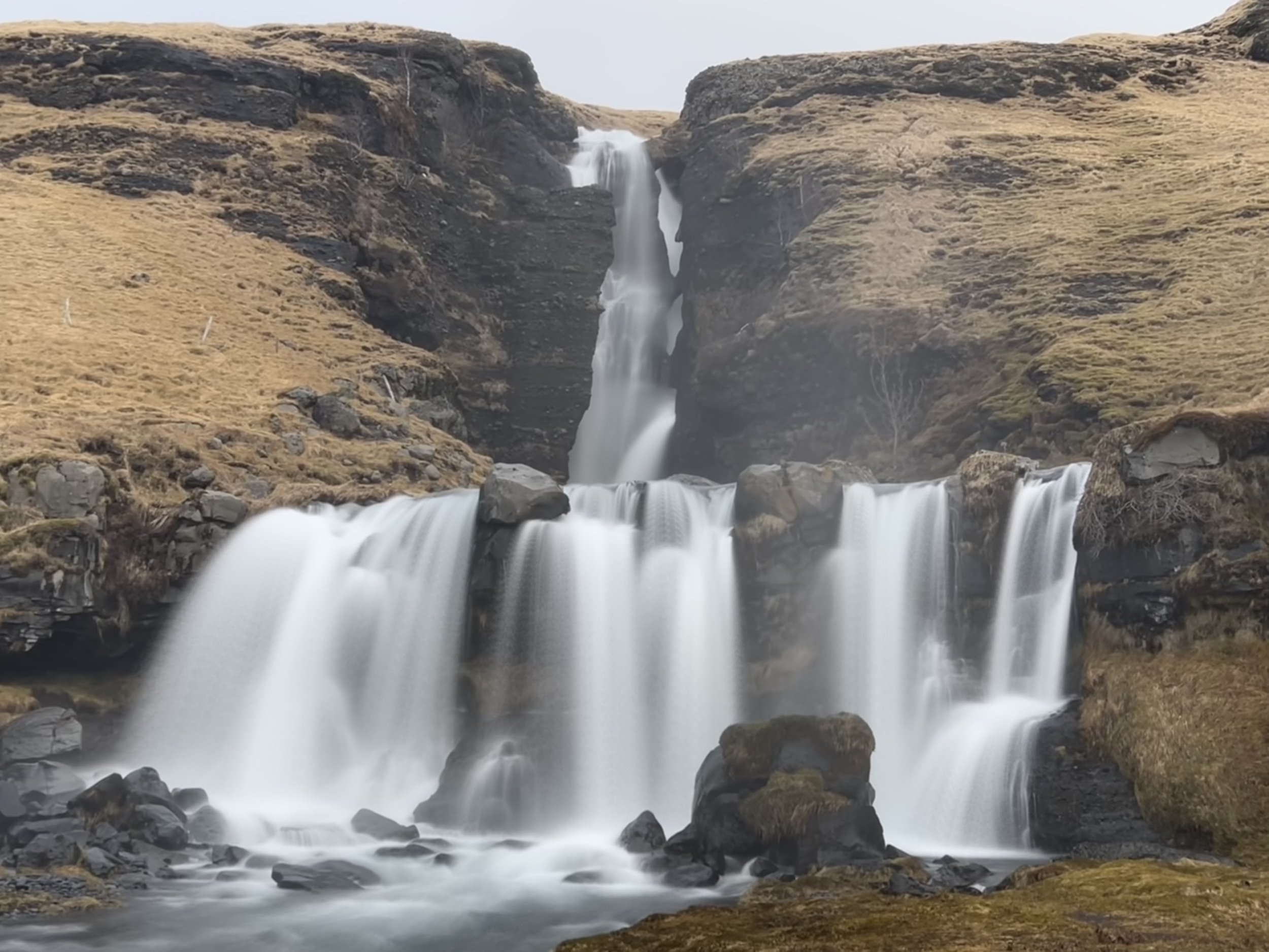
Having said that, the ground was so uneven that I didn’t feel safe going too near to the edge. After a bit of a hike we were rewarded by the sight of a much larger waterfall partway up the mountain, which is a lot higher than you are able to reach via the canyon hike itself, so it felt as if the walk had been worthwhile. Had the season and weather conditions been different I may have been tempted to hike further up to see how close we could get but this time we settled for viewing it from afar and decided to head back down the steep mountainside. So, although not the hike we had been planning for, it was an interesting afternoon’s walk.

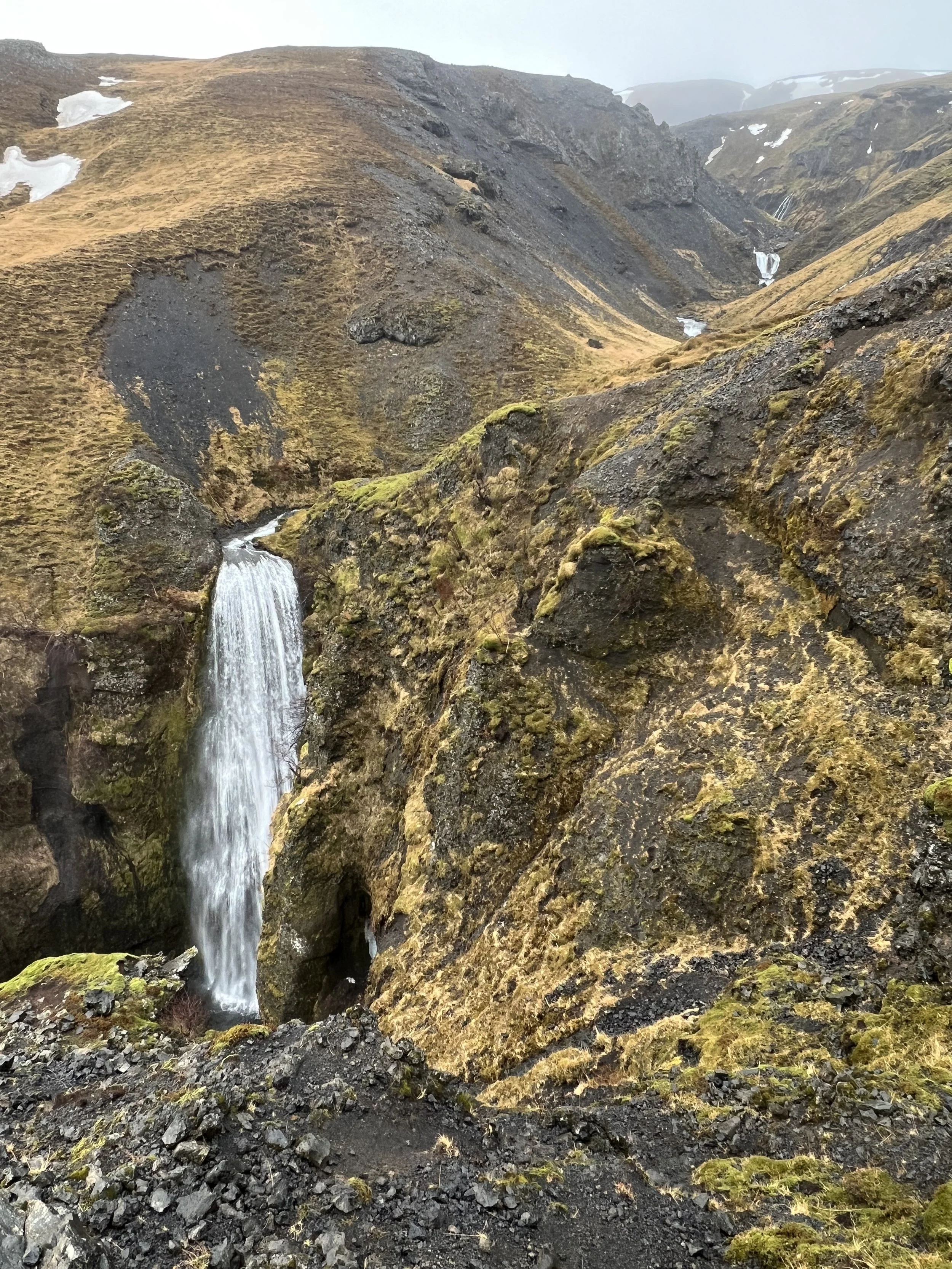
The big waterfall above Nauthúsagil - only visible from the hike above the ravine
When we got back to the car it was still a little too early to check in at our cabin so we decided to check out where it was and then drive on a few miles beyond the farm to find Gluggafoss, which was another waterfall I wanted to see.
Because we were staying on the other side of the Krossá River estuary we had to drive back down to the route one, cross the bridge and then head up the other side of the river. The farm was easy to find, so we passed it and then continued on to Gluggafoss (Window Falls). I think its proper name is Merkjárfoss, but it seems to be universally known as Gluggafoss.
Gluggafoss with its ‘windows’ visible on the right of the main drop
This was a waterfall I had never heard of until doing a bit of research on the area to see what would be worth visiting, and it is most definitely not on the tourist radar. I’m not quite sure why as it’s stunning.
What makes Gluggafoss unique is its geology, the river has created several holes, tunnels and arches in the soft palagonite bedrock through which the water makes its way - these are the ‘windows’ that has given Gluggafoss its name.

A close up of the top window
The main upper waterfall (the bit with the windows) is about 44 metres (144 feet) high and it thunders down into a pool, then widening and cascading some 8.5 metres (almost 30 feet) down the next drop, as it separates into several separate waterfalls.

According to the information board that has been put up, the architecture here has changed a lot over time. Before 1947 the upper half of the waterfall could hardly be seen, as the water disappeared into a vertical tunnel behind the cliff. It was only visible through the three openings (or windows), one above the other. The water came out of the bottom window forming a beautiful arch (except times when the water level rose in the river, which forced it to gush through all three windows). When the volcano Hekla erupted in 1947 the waterfall changed completely; a 20cm thick layer of ash fell as a result of the eruption, which the river then carried downstream. As it filled with sediment, the vertical tunnel formation nearly disappeared and it is only now that it is slowly returning to its former glory.

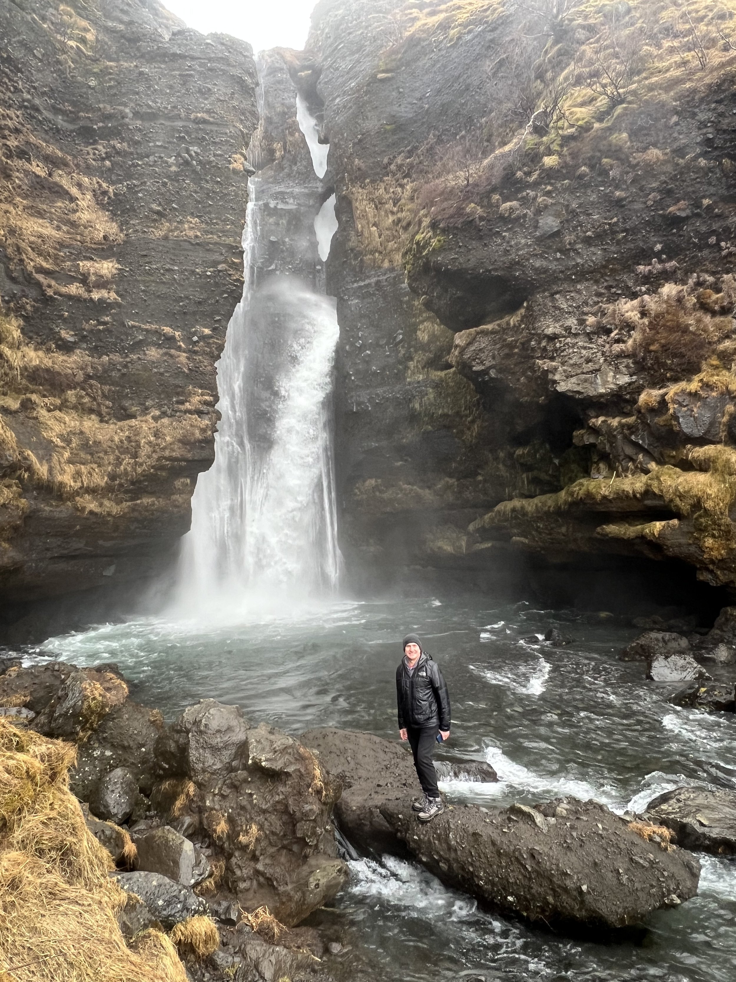
It’s possible to get very close to the waterfall itself - but you do get very wet!
We spent a long while just enjoying the various viewpoints of Gluggafoss’s multiple falls and on another day when we have more time and the conditions are dryer we will come back and climb up the hill to the right of the waterfall so that we can see it from above. Apparently, there is a large cave up there which is well worth seeing, as well as beautiful views of the Eyafjallajökull glacier and the Fljótshlíð area and, of course, several other very pretty waterfalls. As it was, we could see many other waterfalls coming down from the same mountainside - presumably it is because there is so much water making its way down from the glacier as the ice melts that there are so many waterfalls.


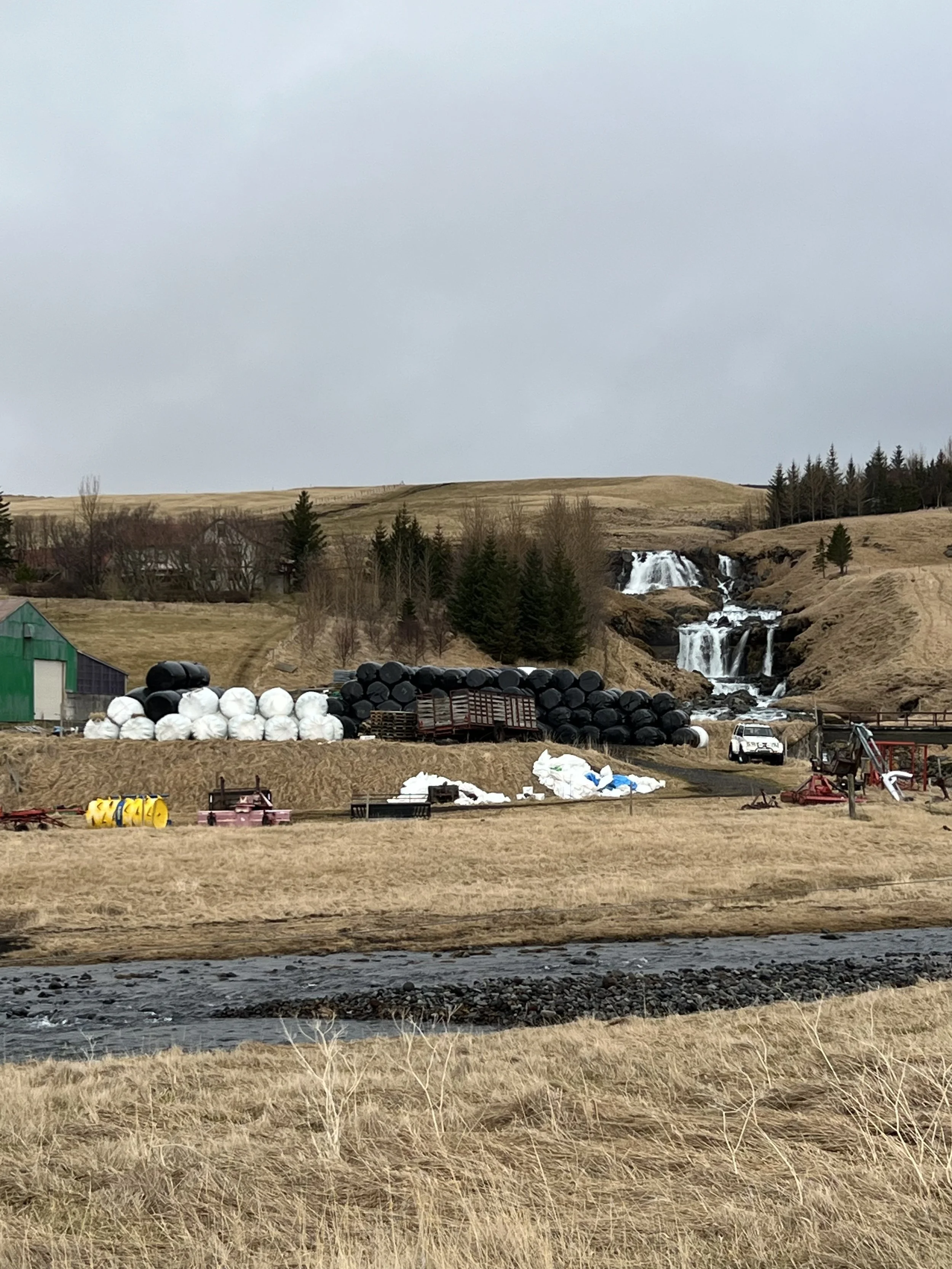
Other waterfalls, including one that forms part of a working farm!
By the time we’d explored the area around Gluggafoss, also visiting the waterfall that was visible to the left of it, which was also quite pretty, we headed back to the farm to check in to the little cabin we’d booked. Rauðuskriður is a working farm and we were lucky enough to meet the farmer while we were exploring the area around our little cabin, and he invited us to meet the animals and to look around the pens and stables.


Enjoying some time with our neighbours
It was rather fun getting to know the resident horses, cows and sheep and making friends. There was also a shared hot tub behind the farmhouse which we were welcome to use and which we had to ourselves. The cabin was well appointed and cosy and we were very comfortable there.

Our little cabin for the weekend
Despite rain through the night, Sunday morning was a lot brighter. There was still some fine drizzle on and off but on the whole it was a much better day so we decided to go and climb Stóra Dímon, the small mountain that was right by the entrance to the farm. Stóra Dímon and its sister mountain Litla Dímon are the high points on the flat estuary. Their names are thought to come from Latin and mean two mountains (Di – two, and mon from mons – mountain) so literally the big one of the two mountains and the little one of the two mountains.
Stóra Dímon seen from Rauðusrkriður farm
Stóra Dímon is only 178 metres high (584 feet) so even the big mountain is really quite little, although it is pretty steep. When we parked at the foot of the mountain we could see the path snaking its way up the side.


Photos don’t show how steep the path actually was
The hike isn't long, I suppose it takes around 20 minutes to get to the top, but it's so steep that in places we were almost scrambling up the slope rather than walking. Luckily it wasn’t too wet as the rain was more of a fine mist than proper rain, but I was still a little bit wary of slipping on such a steep slope. However, it wasn’t long until we were up on the top and able to enjoy the absolutely incredible view of the Krossá River, which creates a beautiful delta below and all around Stóra Dímon.


Enjoying the views of the estuary (or in Matthew’s case, celebrating just getting up there!)
On the one side of us we could see Rauðuskriður farm where we had stayed, and above the farm houses on the other side of the river was the Eyjafjallajökull volcano and glacier. When the weather is good you can even see the islands of Vestmannaeyjar off the coast, but it was far too misty for us to be able to see them this time.

From the top of Stóra Dímon looking inland towards Þórsmörk
We spent a fair while at the top of Dímon just enjoying the gorgeous 360 degree views, and were also rewarded with a rainbow! Stóra Dímon has always looked pretty spectacular from the road, but I hadn’t realised just how beautiful the views would be from the top.

A beautiful rainbow arching over Rauðuskriður farm
After carefully making our way back down the same path we’d climbed, we set off on a leisurely trip back to Reykjavík, via Gluggafoss for a second look and a few more photos and a stop in Selfoss for lunch. Over a delicious lunch in a bustling restaurant that was full of locals (always a good sign) we booked Sky Lagoon for the mid-afternoon. By then the rain had stopped and we spent a very lazy afternoon and evening in the warmth of the lagoon. We decided to top off a rather indulgent weekend with a trip to Rok, one of our favourite restaurants. It has been a good couple of days; very relaxed, and it was lovely to finally be on the move again and to be able to go away for the weekend. The weather wasn’t the best, but after the last few weeks of really dreadful weather, and the coldest winter Reykjavík has had for 40 years, it was wonderful to go out walking in nothing more than a little rain. And we will just have to try again for the Nauthúsagil hike in the summer!
